Description of the presentation by individual slides:
1 slide
Slide description:
Artem Dmitriev, student of class 5 “A” Head Dmitrieva Marina Gennadievna Presentation on the world around us on the topic “THE SEA OF AZOV”
2 slide
Slide description:
Sea of Azov - origin of the name In Rus', the Sea of Azov became known in the 1st century AD, and it was called the Blue Sea. After the formation of the Tmutarakan principality, the modern Sea of Azov began to be called Russian. With the fall of the principality, the sea was renamed many times (Samakush, Salakar, Mayutis, etc.). At the beginning of the 13th century. The name Saksi Sea was approved. The Tatar-Mongol conquerors added to the collection of names of Azov: Balyk-dengiz (fish sea) and Chabak-dengiz (chabach, bream sea). It should be considered most reliable that the modern name of the sea comes from the name of the city of Azov. There are a number of hypotheses regarding the etymology of the word “Azov”: by the name of the Polovtsian prince Azum (Azuf), who was killed during the capture of the city in 1067; by the name of the Osov tribe (Assy), which in turn supposedly came from Avestan, meaning “fast”; The name is compared with the Turkic word azan - “lower”, and the Circassian uzev - “neck”.
3 slide
Slide description:
4 slide
Slide description:
Geographical location and boundaries The Sea of Azov is located in the south of the European part of Russia, between 45°17` and 47°17` N. w. and 34°49` and 39°18` E. d. It is a semi-closed inland body of water, connected in its southern part with the Black Sea through the shallow Kerch Strait, and belongs to the Mediterranean Sea system of the Atlantic Ocean.
5 slide
Slide description:
Main characteristics of the Azov Sea The area of the Azov Sea is 39 thousand km2, its volume at the average long-term level is 290 km3, and its average depth is about 7 m. The greatest length of the sea from the Arabat Spit to the Don Delta is 360 km, and the maximum width from north to south is 180 km. Two large rivers flow into the Sea of Azov - Don and Kuban, as well as about 20 small rivers, a significant part of which flows from the northern shore. The Don, flowing in from the northeast, forms a small multi-branch delta in its lower reaches, the area of which is 540 km2. The mouth of the Kuban, located in the southeastern part of the Sea of Azov, is a vast two-arm delta with an area of 4,300 km2. The average total flow of the Don and Kuban after its regulation is 28 km3/year.
6 slide
Slide description:
Water regime of the Sea of Azov The water regime of the Sea of Azov depends mainly on the influx of fresh river waters, atmospheric precipitation falling over the sea and the salty waters of the Black Sea entering it, on the one hand, and on the flow of water from the Sea of Azov for evaporation and runoff through the Kerch Strait to the Black Sea - on the other. The Sea of Azov has established a salinity that is favorable for the habitat of valuable commercial fish.
7 slide
Slide description:
Climate and temperature regime The climate of the Sea of Azov is significantly influenced by the surrounding vast steppe spaces of Southern Ukraine, Ciscaucasia and Crimea with their rather dry climate. In the Azov region, average July temperatures range from +22 to +24°, January temperatures from 0 to +6°, and the average annual precipitation is 300-500 mm. The Sea of Azov is characterized by relatively cold but short winters, mild summers with an even distribution of temperatures, warm autumns compared to spring and high relative humidity. The average annual air temperature on the Sea of Azov ranges from +9 to +11°. In summer, the temperature for all areas is almost the same. The maximum temperature in July is +35 - +40°.
8 slide
Slide description:
Fauna Along the banks of rivers and reservoirs, on the spits of the Sea of Azov there are a lot of waterfowl - geese, ducks, steppe waders, lapwings, red-breasted geese, mute swans, curlews, black-headed gulls, laughing gulls, quacks. The steppe reservoirs are inhabited by the marsh turtle, lake frog, pond frog, some mollusks - reel, pond snail, meadow, crayfish and about 30 species of fish. Fish catch per hectare of surface in the Sea of Azov is 80 kilograms, for comparison in the Black Sea - 2 kilograms, in the Mediterranean - 0.5 kilograms. The Sea of Azov is called the sea of shellfish. It is an important source of food for fish. The most important representatives of mollusks are cordate, sandesmia, and mussel. In terms of biological productivity, the Sea of Azov ranks first in the world. The ichthyofauna is of particular interest. More than 70 species of different fish live directly in the Azov Sea, including: beluga, sturgeon, stellate sturgeon, flounder, mullet, sprat, anchovy, ram, vimbe, shemaya, and various types of gobies.
Slide 9
Slide description:
Ecology The sea is heavily polluted by waste from enterprises in Mariupol (especially the full-cycle metallurgical enterprise OJSC Azovstal), Taganrog and other industrial cities located off the coast. Increased shipping has led to sea pollution and even environmental disasters. In 2007, in the Kerch Strait near the Russian port "Caucasus" due to a strong storm on November 11, 4 ships sank - bulk carriers "Volnogorsk", "Nakhichevan", "Kovel", "Hadji Izmail" (Georgian flag, Turkish shipowner and crew) . 6 ships broke their anchors and ran aground, 2 tankers (Volgoneft-123 and Volgoneft-139) were damaged. About 1,300 tons of fuel oil and about 6,800 tons of sulfur ended up in the sea.
10 slide
Slide description:
Interesting facts about the Sea of Azov The Sea of Azov is the smallest of all the seas washing Russia. Of all the seas in the world, the Sea of Azov is the shallowest, its depth does not exceed thirteen meters at its deepest point. The Sea of Azov is the most distant sea on Earth from any ocean, that is, the most continental. In summer, coastal waters sometimes glow at night. More precisely, the abundant algae that live there glow. In winter, the Sea of Azov is often covered with ice. Sometimes - completely. The second name of the Azov Sea is the Sea of Shellfish.
Sea of Azov -
northeastern
side pool
Black Sea, from
which it
connected by Kerch
strait (width
4.2 kilometers).
Sea of Azov
refers to the seas
Atlantic Ocean.
Location of the Sea of Azov
The longest sea length is 343 kilometers, the largest width231 kilometers; coastline length 1472 kilometers; square
surface - 37,605 square kilometers (this area does not
includes islands and spits, occupying 107.9 square
kilometers). According to morphological characteristics, the Sea of Azov belongs to
to flat seas and is a shallow
a reservoir with low coastal slopes. The greatest depth does not exceed 14 meters, and the average depth
about 8 meters. At the same time, depths up to 5 meters occupy more than
half the volume of the Sea of Azov. The Black Sea is larger than the Sea of Azov
in area almost 11 times, and in volume - 1678 times. And yet Azov
the sea is not so small, it could easily accommodate two
such European countries as the Netherlands and Luxembourg. The underwater relief of the Sea of Azov is very simple - the bottom is almost flat.
The Sea of Azov forms several bays, of which the most
the largest are Taganrog, Temryuk and very isolated
Sivash, which is more correctly considered an estuary. Large islands on
There is no Azov Sea. There are a number of shallows that are partially filled with water and
located near the coast. These are, for example, the Biryuchiy Islands,
Turtle and others.
Biryuchiy Island
Bathymetry of the Azov Sea
Underwater terrainSea of Azov
relatively simple. By
distance from the shore
depths slowly and
gradually increasing
reaching in the central
part of the sea 14.4 meters.
Main bottom area
Sea of Azov
characterized
depth 5-13 meters In the bottom relief of the Sea of Azov
underwater systems are noted
hills, elongated
along the eastern and western
coasts, depths above
which decrease from 8-9
up to 3-5 meters. For underwater
coastal slope of the northern
the coastline is characteristically wide
shallow water (20-30 kilometers)
with depths of 6-7 meters.
Seashores are mainly
flat and sandy.
Fauna
Among the Azovmigratory fish
there are the most valuable
commercial species,
such as beluga, sturgeon,
sevruga, herring, fish
and shemaya.
Marine species
reproduce and
walk in the salty
waters Among them
species are highlighted
permanently living in
Sea of Azov. This -
pilengas, kambalakalkan, glossa, sprat,
perkarina, cat
three-spined fish, needle fish and
all types of bulls
Salinity
The water contains very little salt in the northern partSea of Azov. For this reason the sea is easy
freezes, and therefore, before the icebreakers appear, it
it was unnavigable from December to mid-April.
The southern part of the sea does not freeze and remains
moderate temperature. The Azov coast is not so abundant in the variety of landscapes, in
difference from the Black Sea. But in the smooth curves of the coastline,
sand spits stretching far into the sea, round green hills,
The floodplains overgrown with reeds have their own special charm.
The Sea of Azov is a unique natural object. The importance of preserving it in its pure form is obvious. Each of us understands that our sea is a source of both material and spiritual wealth. The main problems of the Sea of Azov are its unsatisfactory ecological condition, caused by the increased economic activity of coastal countries. In 2008, Russia and Ukraine exceeded industrial production volumes. Accordingly, the release of pollutants into the sea through wastewater and maritime transport has increased.

The Sea of Azov is the northeastern basin of the Black Sea, with which it is connected by the Kerch Strait. This is the shallowest sea in the world, its depth does not exceed 14 meters. The extreme points of the Sea of Azov lie between 45° and 47° N latitude. and between 33° and 39° east. d. Its longest length is 343 km, its largest width is 231 km; coastline length 1472 km; surface area km². According to its morphological characteristics, it belongs to the flat seas and is a shallow body of water with low coastal slopes. The Sea of Azov is the most continental sea on the planet. In winter, partial or complete freezing is possible. As a rule, ice formation is typical for January, but in cold years it can occur a month earlier. The ichthyofauna of the Azov Sea currently includes 103 species and subspecies of fish.

The rivers flowing into the Sea of Azov are heavily polluted by waste from metallurgical and chemical enterprises, as well as municipal wastewater. The Sea of Azov, which was the most productive in the world, has now practically lost its fishing significance. The main sources of pollution in the Azov Sea are industrial enterprises and ports of the city of Mariupol. The Azovstal and Azovmash metallurgical plants annually discharge over 800 million m3 and over 850 million m3 of wastewater. In the effluents, the maximum permissible concentration for nitrogen is 2.74 times, iron is 4 times, copper is 2.26 times, and oil products is 2.26 times. The treatment facilities of coastal ports are not working efficiently enough.

Water pollution with oil and petroleum products occurs as a result of maritime cargo transportation and port activities. The biggest disaster in recent years was when 10 ships were thrown ashore in the Kerch Strait due to a storm. 3 thousand tons of fuel oil and about 7 thousand tons of sulfur got into the sea, which led to pollution of the bottom of the Sea of Azov, the death of a large number of fish, dolphins and birds. The concentration of petroleum products in the Sea of Azov exceeds the maximum permissible concentration by 10 times. Oil spills impair the oxygen exchange between water and air, and pesticides poison aquatic organisms. The lack of a sufficient number of adequate port facilities to handle environmentally hazardous cargo leads to significant pollution of marine and port waters.

One of the main causes of environmental problems of the sea is the construction of reservoirs on the main rivers feeding the sea (Don, Kuban), the transformation of these reservoirs into giant industrial settling tanks and the uncontrolled increase in the discharge of pesticides into the sea from adjacent agricultural areas. Agricultural runoff, which contains many toxic chemicals, poses a particular danger to the Azov Sea ecosystem. Mineral fertilizers - nitrates and phosphates - also have a detrimental effect on ichthyofauna. With the runoff of small rivers, about 12% of undigested nitrogen fertilizers, 13% of phosphorus fertilizers and 6% of pesticides enter the basins of the Azov Sea.

The Sea of Azov is on the verge of an environmental disaster. In my opinion, the main problem is that the modest amounts budgeted for measures to protect and reproduce the marine environment are not fully spent or are used for other purposes. Also, a rather significant problem is the low environmental awareness of CIS citizens, which needs to be increased, and this is the task of the state to the same extent as the task of citizens, because if you don’t start saving the Azov Sea now, which is already on the verge of an environmental disaster, the sea could suffer very sad fate.

Sea of Azov
Prepared by:
a history teacher
MKOU Maninskaya Secondary School
Bosyuk Alina Sergeevna
year 2014

a brief description of
Location
South-east of Ukraine, south-west of Russia
Coastline length
Greatest depth
Average depth
Catchment area
Flowing rivers
Don, Kuban, Eya, Kalmius
The extreme points of the Sea of Azov lie between 45°12′30″ and 47°17′30″ north. latitude and between 33°38′ (Lake Sivash) and 39°18′ east. longitude

View from space
Sea of Azov

History of the study
There are three stages in the history of the study of the Sea of Azov:
1. Ancient (geographical) - from the time of Herodotus to the beginning of the 19th century.
2. Geological-geographical - XIX century. - 40s of XX century.
3. Complex - mid-XX century. - Today.
The first map of Pontus Euxine and Maeotis was compiled by Claudius Ptolemy, who also determined the geographical coordinates for cities, river mouths, capes and bays of the Azov Sea coast.
Claudius Ptolemy
Map of Claudius Ptolemy


Origin
From a geological point of view, it is a young basin.
The history of the emergence of the Sea of Azov is closely connected with the geological past of the Crimea, the Caucasus, the Black and Caspian Seas. Under the influence of internal forces, the earth's crust either fell or rose in the form of mountain ranges, which then, cut off by the work of flowing waters and weathering, turned into plains. As a result of these processes, the waters of the World Ocean either flooded individual areas of land or exposed them, or, as geologists say, transgressions (advance) and regressions (retreat) of the seas were observed.
Only in the Cenozoic era (the era of new life) did the outlines of the continents and individual seas, including the Sea of Azov, become the way we see them on modern maps.

Coastline
The coast of the Azov Sea is less picturesque and diverse than the Black Sea. But it also has its own, unique beauty. The steppes come close to the sea, and in some places there are floodplains overgrown with reeds. The shores are treeless, sometimes low and flat, with a sandy and shell beach, sometimes low but steep, composed of yellow loess-like loams. The coastline of the sea forms fairly smooth curves, and only long sand spits give it some ruggedness. A large number of spits is one of the characteristic features of the shores of the Azov Sea.

Western and eastern banks
Mostly flat and monotonous. Near the mouths of rivers, there are floodplains. Most of the coast is bordered by sand and shell beaches.
The southern part of the eastern coast, approximately from the northern branch of the Kuban River delta to the top of Yasensky Bay, is the so-called Priazovskie plavni, crossed by a large number of branches and eriks.
Sivash Bay

South coast
The southern coast of the Sea of Azov, formed by the northern sides of the Kerch and Taman peninsulas, is hilly and steep; In some places, rocky headlands jut out from it. The vast Temryuk Bay juts into the eastern part of the southern coast, and the Kazantip and Arabat bays into the western part. The banks of the Kerch Strait are high. It contains Kamysh-Burunskaya and Kerch bays, as well as the vast Taman Bay. In some places, sand spits protrude from the shores of the strait, of which the largest are the Tuzla and Chushka spits.

North Shore
The northern coast of the sea - abruptly ends in the sea, in many places cut through by beams.
A characteristic feature is the presence of low and long shallow braids.
The Fedotov, Obitochnaya and Berdyanskaya Bereg spits are noted; thanks to them, the Utlyuksky Estuary bays were formed, bounded by the Fedotov Spit and its continuation - the Biryuchiy Island Spit, Obitochny Bay, located between the Fedotov and Obitochnaya spits.
Berdyansk Spit
Living braid
Belosaraysky Bay

Northeast coast
Its part is the vast but shallow Taganrog Bay, stretching eastward for almost 75 miles. Several small shallow bays, bounded by spits, jut into its shores. On the southern side of the bay is the shallow Yeisk estuary.
Taganrog Bay
Yeisk Estuary

 freezes 1979-1982 In the southern part, salinity = does not freeze period relative to humidity ‰ 10.9 ‰, by 2000 11 ‰ 1977 salinity 13.8 ‰, in Taganrog Bay - up to 11.2. In a larger area of the sea, the water became salinized to 14-14.5‰ During the 20th century. rivers flowing into the Sea of Azov were blocked to create reservoirs. What caused the increase in salinity." width="640"
 Scheme of increasing water salinity
Before regulation of the Don from 1‰-10.5‰ at the mouth of the Don and to the central part of the sea and 11.5‰
(Changed near the Kerch Strait)
Creation of the Tsimlyansky hydroelectric complex
In the northern part, salinity = freezing
In the southern part, salinity = does not freeze
period relative to humidity ‰
10.9 ‰, by 2000 eleven‰
1977 salinity 13.8‰, in Taganrog Bay - up to 11.2. In a larger area of the sea, the water became salinized to 14-14.5‰
During the 20th century. rivers flowing into the Sea of Azov were blocked to create reservoirs.
What caused the increase in salinity.

S catchment area = 586,000 km².
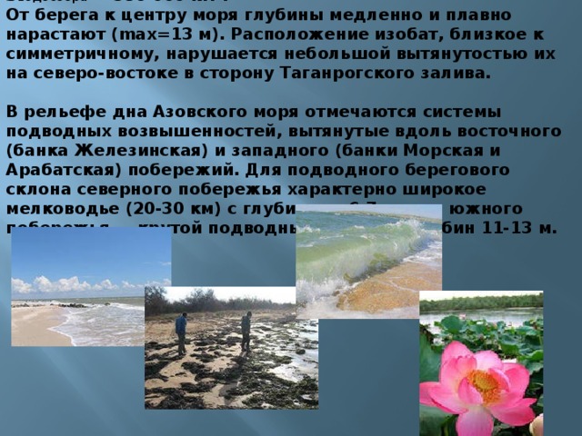
From the shore to the center of the sea, the depths slowly and smoothly increase (max=13 m). The location of the isobaths, close to symmetrical, is disrupted by their slight elongation in the northeast towards the Taganrog Bay.
The bottom topography of the Sea of Azov shows systems of underwater elevations stretched along the eastern (Zhelezinskaya Bank) and western (Morskaya and Arabatskaya Banks) coasts. The underwater coastal slope of the northern coast is characterized by wide shallow water (20-30 km) with depths of 6-7 m, while the southern coast is characterized by a steep underwater slope to depths of 11-13 m.

Currents
Sea currents are dependent on the very strong north-eastern and south-western winds blowing here and therefore change direction very often. The main current is a circular current along the shores of the Sea of Azov in a counterclockwise direction.

Temperature
Temperature
tavg.il. °C
Azov region
Sea of Azov
tavg.jan. °C
Southeast
Western
Eastern
Northeastern

Temperature regime of surface waters
The coastal parts of the sea and the Taganrog Bay are covered with a continuous ice cover. In the central part of the Sea of Azov and in the Kerch region, the ice is floating.
Temperature
Northern and eastern parts
t °C January
Western and southern
(Off the coast)
Ice cover
4-4.5 months from December to March

Biota
Ichthyofauna includes 103 species and subspecies of fish belonging to 76 genera, and is represented by anadromous, semi-anadromous, marine and freshwater species.
The Sea of Azov has no equal in the world in terms of the number of plant and animal organisms. In terms of fish productivity, that is, the number of fish per unit area, the Azov Sea is 6.5 times higher than the Caspian Sea, 40 times higher than the Black Sea and 160 times higher than the Mediterranean Sea.

Migratory fish species feed in the sea until they reach sexual maturity, and enter the river only to spawn.
Among the Azov migratory fish there are the most valuable commercial species, such as beluga, sturgeon, herring, vimba and shemaya.
Semi-anadromous fish include common species such as pike perch, bream, ram, sabrefish and some others.

Marine species breed and feed in salty waters.
Among them, species that permanently live in the Sea of Azov stand out.
These are pelengas, flounder, glossa, sprat, perkarina, needle fish and all types of gobies.
bearing
sprat
percarina
needlefish
gloss
flounder
Freshwater species live in one area of the reservoir and do not make large migrations. These species usually inhabit desalinated sea areas. Here you can find fish such as sterlet, silver crucian carp, pike, ide, bleak
bleak
pike
goldfish

There is a large group of marine fish that enters the Sea of Azov from the Black Sea, including those that make regular migrations. These include: Azov anchovy, Black Sea anchovy, Black Sea herring, red mullet, singil, sharpnose, mullet, Black Sea Kalkan, horse mackerel, mackerel, etc.
mullet
Black Sea anchovy
mullet
horse mackerel
mackerel
Black Sea Kalkan
Azov anchovy

Vegetation
Hyponeuston consists of living organisms, plants that live under a film of surface tension. These are the majority of organisms. The hyponeuston plays a huge role in the life of the sea - it is a nursery for the young of many species of fish and invertebrates, and a source of food for sea inhabitants.
Epineuston - it includes species that live on the upper, airy side of the surface film. These are some insects, as well as the microscopic population of foam flakes: bacteria, protozoan algae, etc. As a rule, each inhabitant goes through two or more life forms throughout its life

Plankton combines all the plants and organisms that penetrate the entire thickness of water from the bottom to the surface (the entire habitable layer).
They move with the help of currents.
Phytoplankton plays a huge role in the life of the sea. It is the main link in the food relationships of the pelagic zone.
Zooplankton. Zooplankton of the Black Sea includes almost all animals - from single-celled animals to fish larvae and eggs.

Seaweed
Blue-green algae
Brown algae

- The main fishing reservoirs of the country;
- Oil reserves under the seabed;
- It is a major transport artery of the country;
- International shipping routes;
- Recreational purposes (hundreds of health resorts on the shores of the Azov Sea)
- Study of the salinity regime and the choice of ways to prevent progressive salinization of the Azov Sea;
- Comprehensive assessment of the effectiveness of the impact of the projected Kerch hydroelectric complex;
- Development of an economic-ecological model of the Sea.

Ecological problems
- The sea is heavily polluted by waste from enterprises in Mariupol, Taganrog and other industrial cities located off the coast;
- In 2007, in the Kerch Strait near the Russian port "Caucasus" due to a strong storm on November 11, 4 ships sank - bulk carriers "Volnogorsk", "Nakhichevan", "Kovel", "Hadji Izmail" (Georgian flag, Turkish shipowner and crew) . 6 ships broke their anchors and ran aground, 2 tankers (Volgoneft-123 and Volgoneft-139) were damaged. About 1,300 tons of fuel oil and about 6,800 tons of sulfur ended up in the sea.

- Storms on the Sea of Azov are accompanied by numerous tragedies - the loss of ships, destruction of coastal structures, and loss of life.
- On the Sea of Azov, the north wind is called tramontane, and the northeast wind is called nor'easter.
- Severe winter comes unexpectedly in some years. The emerging ice fields and hummocks are reminiscent of the Arctic.
- Various atmospheric phenomena - tornadoes, black storms, unusually large hail - complete the picture of complex and unusual processes in the sea. Many of these processes do not always have clear explanations.
- The most dangerous phenomena - surge waves - are known in the Sea of Azov. They lead to real disasters, thousands of victims among residents of coastal areas.
- Emissions of flammable gases from the seabed cause explosions, the activity of so-called mud volcanoes, and even the appearance of islands in the Sea of Azov.

List of used literature
- Dobrovolsky A.D., Zalogin B.S. Seas of the USSR. M., Moscow State University Publishing House, 1982;
- http://azov.tv/azovsea.html;
- http://npamir.narod.ru/07/006.htm;
- http://omop.su/1000/05/113372.php;
- http://ru.wikipedia.org;
- http://www.azovskoe.com/hozussr.php;
Description of the presentation by individual slides:
1 slide
Slide description:
2 slide
Slide description:
The Sea of Azov is an inland sea in eastern Europe. This is the shallowest sea in the world, its depth does not exceed 13.5 meters. Sea of Azov near the village of New Yalta, Donetsk region Location Southeast of Ukraine, southwest of Russia Length 380 km Width 200 km Area 39,000 km² Volume 256 km³ Coastline length 1,472 km Maximum depth 13.5 m Average depth 8 m Catchment area 586,000 km² Flowing rivers Don, Kuban, Eya, Kalmius
3 slide
Slide description:
General information The extreme points of the Azov Sea lie between 45°12′30′ and 47°17′30′ north. latitude and between 33°38′ (Sivash) and 39°18′ east. longitude Its greatest length is 343 km, its greatest width is 231 km; coastline length 1472 km; surface area - 37605 km². (this area does not include islands and spits, which occupy 107.9 sq. km). According to morphological characteristics, it belongs to the flat seas and is a shallow body of water with low coastal slopes
4 slide
Slide description:
The underwater relief of the sea is relatively simple. As you move away from the coast, the depths slowly and smoothly increase, reaching 14.4 m in the central part of the sea. The main area of the bottom is characterized by depths of 5-13 m. The area of greatest depths is in the center of the sea. The location of the isobaths, close to symmetrical, is disrupted by their slight elongation in the northeast towards the Taganrog Bay. The 5 m isobath is located approximately 2 km from the coast, moving away from it near the Taganrog Bay and in the bay itself near the mouth of the Don. In the Taganrog Bay, the depths increase from the mouth of the Don (2-3 m) towards the open part of the sea, reaching 8-9 m at the border of the bay with the sea. In the topography of the bottom of the Sea of Azov, systems of underwater hills are noted, stretched along the eastern (Zhelezinskaya Bank) and western (Morskaya and Arabatskaya banks) coasts, the depths above which decrease from 8-9 to 3-5 m. The underwater coastal slope of the northern coast is characterized by wide shallow water (20-30 km) with depths of 6-7 m, while the southern coast is steep underwater slope to depths of 11-12 m. Bathymetry
5 slide
Slide description:
The drainage area of the Azov Sea Basin is 586,000 km2. The seashores are mostly flat and sandy, only on the southern coast there are hills of volcanic origin, which in some places turn into steep mountains. Sea currents are dependent on the very strong north-eastern and south-western winds blowing here and therefore change direction very often. The main current is a circular current along the shores of the Sea of Azov in a counterclockwise direction.
6 slide
Slide description:
In terms of biological productivity, the Sea of Azov ranks first in the world. The most developed are phytoplankton and benthos. Phytoplankton consists (in%) of: diatoms - 55, peridinia - 41.2, and blue-green algae - 2.2. Among the benthos biomass, mollusks occupy a dominant position. Their skeletal remains, represented by calcium carbonate, have a significant share in the formation of modern bottom sediments and accumulative surface bodies. The hydrochemical features of the Sea of Azov are formed primarily under the influence of the abundant influx of river water (up to 12% of the water volume) and difficult water exchange with the Black Sea. salinity
7 slide
Slide description:
The salinity of the sea before the regulation of the Don was three times less than the average salinity of the ocean. Its value on the surface varied from 1 ppm at the mouth of the Don to 10.5 ppm in the central part of the sea and 11.5 ppm near the Kerch Strait. After the creation of the Tsimlyansky hydroelectric complex, the salinity of the sea began to increase (up to 13 ppm in the central part). Average seasonal fluctuations in salinity values rarely reach 1%. Water contains very little salt. For this reason, the sea freezes easily, and therefore, before the advent of icebreakers, it was unnavigable from December to mid-April. During the 20th century, almost all more or less large rivers flowing into the Sea of Azov were blocked by dams to create reservoirs. This has led to a significant reduction in the discharge of fresh water and silt into the sea.
8 slide
Slide description:
The sea is heavily polluted by waste from enterprises in Mariupol, Taganrog and other industrial cities located off the coast. In 2007, in the Kerch Strait near the Russian port "Caucasus" due to a strong storm on November 11, 4 ships sank - bulk carriers "Volnogorsk", "Nakhichevan", "Kovel", "Hadji Izmail" (Georgian flag, Turkish shipowner and crew) . 6 ships broke their anchors and ran aground, 2 tankers (Volgoneft-123 and Volgoneft-139) were damaged. About 1,300 tons of fuel oil and about 6,800 tons of sulfur ended up in the sea. Ecology
Slide 9
Slide description:
Sun: the solar radiation regime on the Sea of Azov is stable and moderate, it promotes acclimatization, and in terms of the number of sunny days per year, the Azov coast is not inferior to Crimea. Air: the air of the Azov region, saturated with ozone, bromine and iodine ions, infused with the smells of the sea and steppe - an excellent medicine that has a beneficial effect on the endocrine system. Water: The Sea of Azov is the shallowest among the seas of the World Ocean, which is why it warms up earlier than, for example, the Black Sea. The “swimming” season already opens on the May holidays. Azov water contains 92 useful chemical elements, which during bathing easily penetrate the surface of the skin and have a beneficial effect on the body of adults and children. Water has healing properties: swimming in it strengthens the nervous system, improves blood circulation, increases vitality, and enhances the respiratory function of the body. Sun, air and water
10 slide
Slide description:
The fauna of the Azov Sea is very diverse and currently it consists of 103 species and subspecies of fish, which in turn belong to 76 genera, and is also represented by anadromous, semi-anadromous, marine and freshwater fish species. Fauna of the Azov Sea Along the banks of rivers and reservoirs, on the spits of the Azov Sea there are a lot of waterfowl - geese, ducks, steppe waders, lapwings, red-breasted geese, mute swans, curlews, black-headed gulls, laughing gulls, quacks. The steppe reservoirs are inhabited by the marsh turtle, lake frog, pond frog, some mollusks - reel, pond snail, meadow, crayfish and about 30 species of fish. The fauna of the Azov Sea includes about 80 species of fish. The most important species are bream, pike perch, beluga, herring, ram, anchovy, large flounder, and goby.
11 slide
Slide description:
Belugas, in addition to their large weight, are also distinguished by their longevity. They live 70 - 80 years. True, compared to the pike, which lives up to 200 years, and the sea turtle, which lives 400 - 500 years, the beluga's lifespan is short, but compared to the lifespan of other marine fish, it is still significant. Probably not many people know that the age of fish is determined by their scales and cut bones. These parts of the fish's body have annual rings, just like those on trees. There is an expression “roars like a beluga,” but strangely enough, it has nothing to do with beluga. It is not the beluga who roars, but the beluga whale - a northern sea animal. Beluga spawns in the same rivers as other sturgeon. Their caviar is highly valued. However, there are cases when the dangerous bacterium botulinus settles in sturgeon meat, the poison of which is dangerous to humans.
12 slide
Slide description:
Interesting flounder. This fish, flat and often lying on the ground, is distinguished by its ability to quickly change color to match the color of the underlying surface. In the skin of a flounder there are individual colored cells that, when moving, change its color. Scientists put colored glasses on flounders, and the fish tried to copy the color of their glasses. Interestingly, blind flounders are always black. They seem to see darkness in front of them and change body color accordingly. For some reason, flounder is considered one-eyed. This is not true, she actually has two eyes. Flounder weighs up to 15 kilograms and lives up to 25 years. Interestingly, its fry have a body shape that is flattened in a vertical plane; Gradually, one side of the fish’s body begins to develop faster than the other, and the flounder seems to lie on its side.
Slide 13
Slide description:
Fish and sea animals hear perfectly. In relation to fish, it would be more correct to say that they do not hear, but feel, since they perceive the vibrations of water that arise when sounds pass through the surface of their body, especially the lateral line. Fish also have some semblance of an inner ear, auditory ossicles that perceive sounds. It should be recalled that sound travels faster and further in water than in air. Our method of catching mullet in the Black and Azov Seas is based on this property of fish: they are scared away by noise. Fish not only hear sounds, but some of them can make them. For example, scienae, dark croakers, gurnards and other fish found in the Black Sea “talk” to each other by squeezing sounds from their swim bladder (playing it like a drum).
Slide 14
Slide description:
What do these sounds sound like? The gurnard "grinds its teeth" if it is dissatisfied, and when pleased it makes more melodic sounds, croakers "croak", herring "whisper", and horse mackerel "bast" loudly. Dolphins pulled out on deck “grunt”, “meow”, “croak”. Some fish make very loud sounds, such as the dark croaker. When a flock of croakers is at a depth of 40 meters, you can hear them “talking” on the surface of the water. Military sailors believe that during the war, some acoustic mines exploded not from the noise of the ship's propellers, but from the screams of the loudest fish. From this it is clear that the popular expression “dumb as a fish” is not always true.
15 slide
Slide description:
In addition to the sounds that we can hear, fish produce ultrasounds. With their help, they detect food or danger; this largely replaces their vision. It is not surprising, therefore, that blind fish can find food and spawning places just like sighted ones. How fast do fish swim? Which fish are considered the best swimmers? Can a person match the swimming speed of a fish? However, the majority will probably answer the last question in the negative. And perhaps only hydrobiologists can answer the first two questions. This is what they say. The speed of small fish is from 2 to 12 kilometers per hour. The larger the fish, the faster, as a rule, their speed. A shark and a dolphin can easily outrun a passenger ship, and a swordfish can reach speeds of up to 130 kilometers per hour. Man is a very weak swimmer compared to fish. The world champion swimmer cannot reach a speed of more than 6 - 7 kilometers per hour, that is, he swims twenty times slower than the fastest fish.


Magellanic clouds: who are they?
Pepper Steak Sauce Creamy Pepper Sauce
How to create a competent portfolio for a designer
If you dreamed that a house burned down - interpretation of the dream according to the dream book
Accountant's quarterly reports