Rivers entangle all of Russia like a web. If you count them all down to the smallest one, you get over 2.5 million! But the vast majority of them don’t even have names, so it’s better to pay attention to the largest rivers in the country, not forgetting what you can catch in them, because there are a lot of fishermen in Russia.
1. Lena (4400 km)
The longest river in Russia, and at the same time in Siberia, is the Lena. It is also respectable by world standards, since it ranks at the top of the ten longest waterways in the world. Lena takes its beginning from a small lake near Baikal, winds a lot through the mountainous Baikal region until it turns north and rushes to the Laptev Sea, where it forms an extended delta. Together with the latter, it has a length of 4,400 km with a basin area of 2.5 million square meters. km, the water flow in the lower reaches is 16,350 cubic meters. m/s. This is the longest Russian river, flowing entirely through the country, and the largest in the world, completely passing through the territory of permafrost. The Lena still remains one of the cleanest rivers in the world. Man has not yet been able to change its course; he has not built a single dam, hydroelectric power station or other energy structures. In areas remote from human activity, you can still drink water directly from the river.
2. Irtysh (4248 km)

Like most of the large rivers of Siberia, the mighty Irtysh from the depths of the Asian continent heads north until it flows into the Ob, being its main tributary. Their joint water system stretches for 5,410 km, which makes it the seventh longest on Earth. But this is not even the main attraction of the Irtysh, but the fact that it has become the longest tributary in the world, since its own length is 4248 kilometers. In this category, it is significantly inferior to second-place Missouri, which has a length of “only” 3,767 kilometers.
Translated from the Turkic language, Irtysh means “digger,” and this reflects the nature of the river, which very often changes its course, undermining the banks. The Irtysh is fed by meltwater and tributaries. But now floods rarely occur here, since several hydroelectric power stations have been built here, the dams of which regulate the release of water.
On our planet there are areas where a person experiences special sensations: a surge of energy, euphoria, a desire to improve or spiritually...
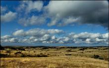
3. Ob (3650 km)
![]()
In the northeast of Asia, in the Altai Territory, near the administrative border with the Altai Republic, two mountain rivers Biya and Katun merge, resulting in the formation of a powerful full-flowing river Ob, the name of which has still not been revealed. The Ob crosses Western Siberia from south to north and after 3,650 kilometers flows into the Kara Sea, more precisely, into a long (800 km) gulf called the Gulf of Ob. The Ob has the largest basin in Russia, occupying almost 3 million square kilometers, and in terms of fullness it is second only to the Yenisei and Lena, bringing 12,300 cubic meters of water to the mouth every second.
4. Volga (3531 km)

The great Russian river Volga has over 150 tributaries; few other rivers on the planet have as many. Taking into account the average current speed of 4 km/h, it is calculated that the water in it reaches the mouth in 37 days. This river even has its own holiday - Volga Day is celebrated on May 20. The entire Volga basin is located on the territory of Russia, it crosses the territories of four republics and 11 regions of the country, and only one small branch of it, Kigach, turns into the territory of Kazakhstan.
And the source of the Volga is located on the Valdai Hills, in the Tver region near the village of Volgoverkhovye. Although not the largest in Russia, the Volga is nevertheless the largest river in Europe. Its basin extends over a third of the European territory of Russia, occupying 1,855 million square meters. km, and water consumption is 8060 cubic meters. m/s. 9 hydroelectric power stations with reservoirs were built on the Volga; half of the country’s agriculture and industry are served with its water.
5. Yenisei (3487 km)

The Yenisei River appears after the confluence of the Big Yenisei (Biy-Khem) and the Small Yenisei (Kaa-Khem). The Yenisei flows for almost 3.5 thousand kilometers only through the territory of Russia, and before that it winds through Mongolia for another 600 kilometers. At the end of the journey, it flows into the Yenisei Bay, which belongs to the Kara Sea. The source of the Yenisei is located near the geographical center of Asia near the city of Kyzyl, in which there is even an obelisk reminiscent of this.
In terms of basin area (2.58 million sq. km), the Yenisei is second only to the Lena; its water consumption is also large - 19,800 cubic meters. m/s. In three places it is blocked by powerful hydroelectric power stations: Sayano-Shushenskaya, Krasnoyarsk and Mainskaya. As for the name of the river, it is associated either with the Tungus word “enesi”, which means “big water”, or with the Kyrgyz “enee-say”, that is, mother river.
The mighty, stormy Yenisei is especially notable for its ice drifts. During the winter, a powerful ice shell grows on the river, from which the river is freed for at least a month. Thousands of tons of ice rush along the river, forming jams here and there that block the flow. As a result, the river overflows its banks and floods the surrounding area. At one time, different cities had to feel the power of this water element - Yeniseisk, Krasnoyarsk, Igarka and Minusinsk.
Russia is huge, Russia is beautiful, Russia is diverse. It is the largest country in the world, with an area of more than 17 million square meters. km. Thanks to the occupied space...
6. Lower Tunguska (2989 km)

This is another Siberian river, which is the right tributary of the Yenisei. The Lower Tunguska flows through the Irkutsk region and Krasnoyarsk region. It winds for a long time along the middle part of the Siberian Plateau until it comes to the Putorana Plateau. Due to the large number of rapids and whirlpools, navigation along the Lower Tunguska is severely limited. Back in 1911, plans were made to connect the Lena and Lower Tunguska near the city of Kirensk, since here they come together to a distance of 15 kilometers, however, the Lower Tunguska flows almost 85 meters above the Lena, and is also not navigable in this place. Therefore, the construction of a connecting canal between them was abandoned due to the high cost and inexpediency of the project.
7. Amur (2824 km)

The Amur River is international - it flows through the lands of Russia, China and Mongolia, and flows into the Sea of Okhotsk in the area of the Amur Estuary. The length of the Amur is 2824 kilometers, and the basin area is 1.855 million square meters. km with a water consumption of 10900 cubic meters. m/s. The Amur flows through 4 different climatic zones: semi-desert, steppe, forest-steppe and forest; 30 different nationalities live on its banks. There is no clarity regarding the origin of the name of the river, but the most common version is from the Tungus-Manchu words “damar” or “amar”. The Chinese call it the Black Dragon River, but in our country the Amur symbolizes the Far East and Transbaikalia.
8. Vilyui (2650 km)

The longest and largest left tributary of the Lena, flowing through the Krasnoyarsk Territory and Yakutia, is called Vilyuy. It has served man since ancient times, giving him water and food. A couple of hydroelectric power stations were built on it. When intensive industrial development of Siberia began, the environmental situation in the Vilyuy basin worsened, causing concern to the indigenous people.
The territory of Russia is huge, so it is not surprising that dozens of waterfalls are scattered across it, in its most diverse corners. Some of them are so...
9. Ishim (2450 km)

Ishim is the left and longest tributary of the Irtysh; it passes through the territory of Kazakhstan and Russia. According to popular legend, the name “Ishim” comes from the name of the son of the Tatar Khan, Ishim, who drowned in a previously nameless river. But there is also a Tatar word “ishimak”, meaning “destroying”. There are two reservoirs on Ishim that are of great economic importance: the local population uses water from them and irrigates fields and gardens.
10. Ural (2428 km)

In the European part of Russia, the Ural River is one of the largest. It descends along the southeastern Black Sea-Caspian slope, running 2,428 kilometers from its very source to its confluence with the Caspian Sea. The area of the river basin is 220 thousand square meters. km. The Ural is a very winding river, it is usually divided into three sections: from the source to Orsk, the middle from Orsk to Uralsk and the lower from Uralsk to the very mouth. A whole network of reservoirs has been built on this river, which provide much-needed water for industry and agriculture.


The most beautiful motorcycles in the world
Which sea is the cleanest in the world?
Top 10 Most Expensive Furs
The largest and most luxurious casinos in the world
Knightly orders of Europe XI - XIII centuries